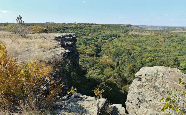
Donets Ridge
Donets Ridge or Donets Upland (Донецький кряж; Donetskyi kriazh). Stretching along the bend in the Donets River, this is the easternmost upland in Ukraine. It extends from the northwest to the southeast. It is 370 km in length and from 50 km (in the east) to 120 km (in the west) in width. In the north the ridge drops abruptly to the valley of the middle Donets River, and in the southeast it drops to the Azov Lowland. In the southwest it meets the Ukrainian Crystalline Shield and the Azov Upland. The Donets Ridge is a folded, mountainous formation, which was built in several phases from the Carboniferous to the Eocene period. Orogenic movements were at their height during the Hercynian cycle of mountain-building between the Upper Permian and the end of the Triassic periods. The ridge was destroyed several times between the Carboniferous and the Eocene periods by external causes such as sea incursions and peneplanation. During the Upper Pliocene, when the Donets Ridge was almost a plain, it underwent its final uplifting. Since then it has been subject to vigorous erosion.
Most of the Donets Ridge is built of immense Carboniferous strata 12,000 m thick. They constitute the basic component of the ridge. The strata of the Lower Carboniferous period are limestone. As the sea alternated with dry land, up to 200 substrata—continental (coal-bearing) and marine (limestone, clay, sandstone)—were formed. Besides Carboniferous strata there are Permian strata, rich in gypsum and rock salt, in the northwest; chalk strata and also Triassic and Jurassic strata in the north and northwest. Tertiary deposits are found only on the periphery of the ridge. Almost all of the Donets Ridge is covered with loess.
Today the Donets Ridge is an undulating upland dissected by valleys and gullies. The highest points of the upland are located on the main watershed, which extends from the upper Kryvyi Torets River in the west to the upper Kundriucha River in the east. Its highest section, the Debaltseve-Ivanivka Ridge, has an elevation of over 300 m (Mechetna Mohyla is 369 m high) and extends for 120 km. The elevation decreases to the north and south, reaching 150 m. Lower ridges, separated by depressions (of which the Bakhmutka and Luhanka depressions are the largest), branch out from the main watershed. The ridges are wide, gently undulating plateaus covered with burial mounds, the most elevated points of the Donets Ridge. In some cliffs the hard strata of sandstone and limestone reach the surface. The plateaus are frequently and deeply dissected by river valleys and gullies, because sharp elevation differences have caused extensive erosion. The valleys are 100–150 m in depth and are particularly picturesque where they cut into hard Carboniferous strata. The right bank of the Donets River (elevation 100 m) consists of hard Carboniferous, Jurassic, and particularly chalk strata and is most picturesque. Like the right bank of the Dnipro River it contrasts sharply with the low left bank for a distance of 300 km. The Donets River is different in the east, where it cuts into anthracite strata, particularly at the mouth of the Kalytva River. The landscape of the Donets Ridge is affected also by anthropogenic forms such as tumuli and sandpits.
The rivers of the Donets Ridge (the Sukhyi Torets River, Kryvyi Torets River, Bakhmutka River, Luhanka River, Lykha River, Bila Kamianka River, Kundriucha River) flow north to the Donets River or (in the case of the Kalmiius River, Miius River, Tuzliv River) south to the Sea of Azov. In the west the Vovcha River and Samara River flow into the Dnipro River. All of these rivers, except the Donets, are shallow and often dry up in summer. The southeastern location and the relief of the Donets Ridge influence some features of its climate. The climate here is more continental than in other regions of Ukraine: the average annual temperature is 6.6°C to 7.8°C, the average January temperature is –6°C to –8°C, and the average July temperature is 21°C to 22°C. The winds are strongest here and come from the east and southeast. In summer dry winds and ‘black storms’ damage crops. Because of the higher elevation the region gets more precipitation than the surrounding steppes: 410–500 mm annually and even more at the highest elevations. Summers bring downpours, but winters bring little snow. Low humidity and a shortage of river water make agriculture and industry difficult. The most common soils are the chernozems—ordinary chernozems with a moderate humus content, low-humus chernozems, and bleached chernozems. Dark-gray chernozems are found in the higher areas, and meadow chernozems are found in river valleys.
The vegetation of the Donets Ridge differs somewhat from that of the surrounding regions. The ridge lies within the belt of multicolored-fescue-feather-grass steppes, but because of its greater precipitation it has some features of the forest-steppe. Oak, ash, maple, linden, and other forests are sometimes found in the gullies or on the watershed of the highest, central section of the ridge. Small hornbeam woods occur here and there, far from the hornbeam’s natural habitat. Larger forests can be found along the Donets River. (For population, economy, and a bibliography see Donets Basin.)
Volodymyr Kubijovyč
[This article originally appeared in the Encyclopedia of Ukraine, vol. 1 (1984).]

