Kakhovka
Kakhovka or Kakhivka [Каховка; Kaxovka]. See Google Map; see EU map: VII-14. A city (2022 pop 34,749), part of the Nova Kakhovka conurbation, in the Kakhovka raion, until 2020 Kakhovka raion center in Kherson oblast, and river port situated on the left bank of the Dnipro River.
History. The area was already settled in ancient times, as indicated by the remains of Bronze Age and Scythian settlements and kurhans. In the Middle Ages this region was contested by Kyivan Rus', but was controlled primarily by the steppe nomads, such as Pechenegs and Cumans (whose anthropomorphic stelae of the 11th–13th centuries were found in the area). The site served as an important crossing of the Dnipro River, with fortifications built to control it (Saint John on the Tavan Island [end 14th century] under the Lithuanian Grand Duke Vytautas the Great [destroyed by Turks in the 15th century], then İslâm Kermen on the left bank, the present site of Kakhovka, in 1492 under the Crimean khan Mengli Girei). İslâm Kermen was stormed by the Zaporozhian Cossacks led by Dmytro Vyshnevetsky (1556), Bohdan Ruzhynsky (1576), Mykhailo Doroshenko (1628), and Ivan Sirko (1660, 1671, 1672, and 1673). The fort was destroyed by Ukrainian forces led by Hetman Ivan Mazepa during the Dnipro Campaign in 1695.
Kakhovka, first mentioned in 1791, was established at the site of İslâm Kermen as a frontier settlement (sloboda) by Colonel Dmitrii Ovsianiko-Kulikovsky, who named it in honor of General V. Kakhovsky, the governor of Tavriia oblast (1784–88) and then of Katerynoslav vicegerency (1788–94). Until 1796 Kakhovka was part of Tavriia oblast, after 1797 of the New Russia gubernia. An important center of the chumak salt wagon trade, it gained town status in 1840 and in 1861 became a volost center in the Dnipro county of Tavriia gubernia. In the second half of the 19th century, it became the largest grain and wool trading center in Tavriia and the largest employment exchange for agricultural laborers in southern Ukraine.
In 1886 the town had 99 houses with 611 residents, an Orthodox church and a Jewish synagogue, a school, a sausage plant and 2 steam grain mills, docks for log rafts and a steam wood mill, 34 market stalls, and 2 annual fairs. In 1897 it had about 1,200 residents. By 1900 Kakhovka gained some industries: an electricity-generating station, a farm machinery plant, a wheel-making plant, a distillery, a brewery, and non-alcoholic beverages plant. It had 6 schools, a library and an infirmary.
In March 1917 a committee was formed for self-administration, comprising local merchants. Although part of the Ukrainian National Republic in 1918, the town was occupied by the Red Army and the White Volunteer Army several times thereafter, was declared a city in 1919, and saw fierce battles between the Red (led by V. Blukher) and White (led by Petr Wrangel) forces (August to October 1920).
As part of the Ukrainian SSR from 1921, it became a raion center in 1923, first within the Kherson okruha (1923–30), then Odesa oblast (1932–44) and Kherson oblast (1944–). Its population in 1926 was 7,490, by ethnicity (in percent) Ukrainian (34.8), Jewish (32.6), Russian (29.9), German (1.2). In the late 1920s and 1930s the languages of instruction in schools were Russian and Ukrainian; there was even a Yiddish 7-year school in Kakhovka. By 1939, despite political repressions and the Famine-Genocide of 1932–3, the population of the city had grown to 12,600, of whom 1,072 or 8.5 percent were Jews.
During the Second World War the city was in a combat zone and then under Nazi German occupation (1 September 1941 to 2 November 1943); organized opposition was suppressed and the remaining Jewish population was exterminated. While some 3,600 Kakhovka residents were awarded medals for their military service, over 4,000 died in combat.
Kakhovka’s postwar recovery was rapid. The construction of the Kakhovka Hydroelectric Station, the second-largest of the Dnipro Cascade of Hydroelectric Stations (1950–6), with a railway and highway crossing on top of the dam 8.5 km downriver from the city and of the new city of Nova Kakhovka alongside the dam, spurred industrial development and population influx. It continued with the construction of the North Crimean Canal (1956–63) and, near its inlet at the Kakhovka Reservoir, the consolidation of four Nova Kakhovka suburbs into the adjacent city of Tavriisk (1983); then the construction (1967–91) of the Kakhovka Canal (its inlet 8 km E of Kakhovka) and irrigation system. Kakhovka’s population grew quickly: 19,100 (1959), 38,700 (1970), 38,742 (1979) and 42,895 (1989).
Following the 1991 Ukraine’s Declaration of Independence, industries were privatized, some started with foreign direct investment. Kakhovka’s Holy Protectress Cathedral (partly destroyed and repurposed in 1937) was re-built (1994–8); other faiths (Protestant Evangelists, Christian Baptists, Seventh-Day Adventists, and Jehovah’s Witnesses) established their houses of worship. Schools were modernized and instruction in the Ukrainian language was reintroduced. The population of the city grew to 44,600 in 1994, then with the aging of population began to decline: 38,238 (2001), 36,944 (2016), 34,749 (2022). According to the 2001 census, the ethnic composition of the city’s population was (in percent): Ukrainians (82.10), Russians (15.12), Belarusians (0.68), Roma (0.51), Moldavians (0.24), and many others (1.35). By mother tongue, however, the percentages were: Ukrainian (73.85), Russian (25.26), Roma (0.24), Belarusian (0.15), Armenian (0.07), Romanian (0.07), and others (0.64), reflecting the legacy of Russification.
The Russian Federation’s annexation of the Crimea in 2014 spurred de-Sovietization of Kakhovka’s street names and the removal of some statues (2015–16). The Russian full-scale invasion and the capture of Kakhovka (24 February 2022) caused considerable destruction; Russian military were compelled to put down daily demonstrations against the occupation (6 March to 3 April 2022). As of August 2025 the city is on the embattled front line along the Dnipro River, held by Russian troops.
Economy. Kakhovka was known for its 1) electric-welding equipment plant (started in 1929 by making parts for tractor engines, then other agricultural and construction equipment; in 1958 it was retooled to produce electric welding equipment; in 1964 it got scientific support with the establishment in Kakhovka of a branch of the Institute of Electric Welding of the Academy of Sciences of the Ukrainian SSR; in 1994 it was privatized as PJSC Kakhovka Plant of Electric Welding Equipment [KZESO], a production and engineering company specializing in the development and manufacturing of welding equipment and track machinery for domestic and export markets). It also had 2) the ‘Silhospahrehat’ farm equipment repair plant, 3) the experimental mechanical factory (making machines for food processing plants) and 4) the ‘Fregat’ irrigation equipment (to supply the expanding Kakhovka Irrigation System [built 1967–91]). Of particular significance after 1991 became food processing: 5) the dockside grain elevator and 6) 6 food products plants in an industrial park serviced by a rail spur, the largest such complex in Eastern Europe. They were: a) Apk Dom Ahro (grain and oilseed milling), b) Cargill oil extraction plant, c) Ahro Alians (distributor of fresh fruit and vegetables), d) Gelios-1 (pickled vegetables), e) Green Team (processor of vegetables), and f) Chumak (founded by Swedish entrepreneurs in 1996, produced ketchup, mayonnaise, pasta, salad dressings, cooking sauces, canned vegetables, marinated vegetables, tomato juice and sunflower oil, halted its operations in 2022 and moved its offices to Kyiv). Other industries included 7) reinforced-concrete materials, 8) furniture, 9) cosmetics, 10) plastic artifacts and 11) leather goods.
Administration services in Kakhovka included city hall, courts, police, and utilities. The city also housed the Kakhovka raion council until the 2020, when the much larger Kakhovka raion was formed; then its raion council moved to Nova Kakhovka. Uniquely, the Consulate of Sweden opened in Kakhovka in 2000, catering to Swedish tourists visiting the nearby Gammalsvenskby in Zmiivka (9 km NE of Kakhovka, across the Dnipro River).
Services include a central market and other shopping areas, 11 bank branches, a regional hospital and other clinics, 3 hotels (Dom, Privat and Tavriya), an inter-city bus depot and the Kakhovka passenger train station and a freight depot in Tavriisk (7 km SW of Kakhovka’s city center); a small airfield within its city limits is for small sport planes or crop spraying service.
Education and sport. Educational institutions in Kakhovka included 7 schools (of which 2 were specialized for training in foreign languages) with 4,000 pupils, 8 preschool establishments with over 1,500 children, 3 extracurricular activity schools (for young technicians, young naturalists, and young artists), a youth sports school, and the interschool training and production complex. A service lyceum preparing professional hairdressers, beauticians, tailors, manicurists-pedicurists operated from 1969 to 2021. There were two libraries (one each for adults and for children), two movie theaters, and the newspaper Kakhovs'ka zoria. Two radio frequencies were broadcasting from Kakhovka.
There were 9 sports organizations in the city for youth and adult fitness. Sports facilities of the youth sports school include the ‘Avanhard’ Stadium (in the old city center, built in 1952, with 1,660 seat capacity, (home of the Avanhard Kakhovka Sports Club, 1980), acquired by the electric-welding equipment plant in 1998, but was neglected and sold) and the newer (1988) well-maintained ‘Olympic’ Stadium (home of the re-named Meliorator Kakhovka Sports Club) next to the ‘Meliorator’ Palace of Culture and youth sports school in the newer upscale Svitlove district of the city.
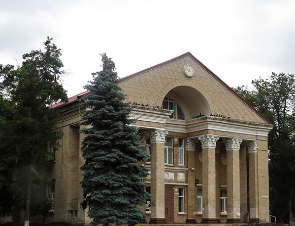
Culture. Kakhovka had several cultural venues until the Russian Federation’s invasion: 1) The city’s Palace of Culture supported 6 folk and 5 exemplary amateur groups, over 10 clubs and amateur associations. 2) The Arts School had the folk dance collectives ‘Nadiya’ and ‘Radist’ that were winners of oblast and national festivals. 3) Notable festivals staged in Kakhovka included: a) the international festival ‘Tavrian games’—a well-known music festival in Ukraine initiated by Mykola Bahraiev—was held in Kakhovka (1992–2010), where 170 renowned artists from 16 countries performed; b) the all-Ukrainian bike-rock festival, ‘Tachanka’, celebrating the motorcyclist’s day (2007–).
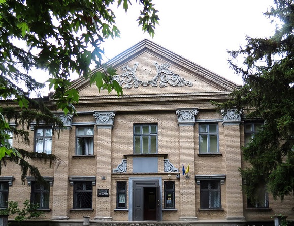
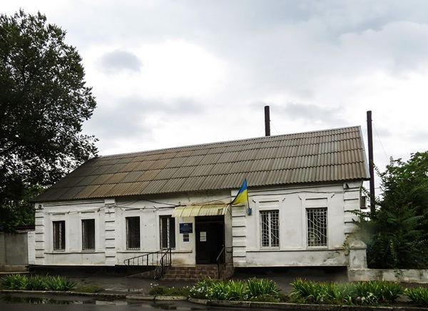
4) The Kakhovka Historical Museum, attracting up to 10,000 visitors annually, featured 16,500 artefacts and documents, with diagrams, maps and photographs. Themes included local prehistory and antiquity, the history of this city and its region, the world wars (1914–20, 1941–44), the construction of the Kakhovka Hydroelectric Station and the Kakhovka Irrigation System. The collection began with 147 documents in 1940, evacuated during the Second World War to Astrakhan, reopened in 1957 in a former merchant home, became a branch of the Kherson Regional Studies Museum in 1965, re-located to the former Rossiia Hotel in 1967 and in 1991 to the former Kakhovka Communist Party Headquarters. In November 2022 its contents were removed by Russian forces and taken to the Crimea.
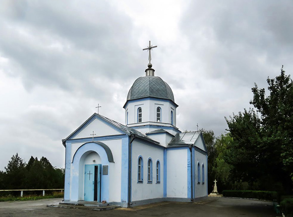
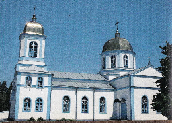
5) The Holy Protectress Cathedral of the Ukrainian Orthodox Church-Moscow Patriarchate is of local historic significance, but not the original building. The first wooden church (1791–1849, funded by Colonel D. Ovsianiko-Kulikovsky), was replaced in 1861 by the original cathedral (funded by M. Ovsianiko–Kulikovsky). A masonry 3-story structure with a school and an 8-story bell tower, it had nearly 7,000 parishioners at the time of its closure in 1923 when it was repurposed; in 1937 it was destroyed by the Soviets, its remains used by the local military administration. During German occupation, religious observance revived in a separate building, but Rev. Savelii Tsybulnykov, who then served, was later imprisoned (1944–54) in a GULAG labor camp. In 1945, Soviet authorities allowed for the registration of the parish with an approved priest and a building to be adopted for religious use. Following the 1991 Ukraine’s Declaration of Independence, the Holy Protectress Cathedral of the Ukrainian Orthodox Church-Moscow Patriarchate, now with a 3–story bell tower, was re-built (1994–98); separate structures for its Sunday school, library and other facilities were added later (2001).
6) Monuments are mainly of the Soviet period. The monumental ones are: a) the Legendary Machine-gun Cart, a bronze sculpture of a machine gun cart (used by the horse regiments of the Red Army in the steppes of southern Ukraine) drawn by 4 galloping horses with 3 men on it (dimensions: 8 m high, 18 m long, 9 m wide, metal weighing 78 tons, made in Leningrad in 1967), installed on a rise at the site of Gen Blukher’s command post; b) the Girl in a Greatcoat, a young woman (in a military uniform with a rifle on her back) at the Civil War Heroes Square (originally life-size, in gypsum, 1955, replaced in 1983 with a 7 m tall copper sculpture on a die amid cement plates symbolizing wartime ruins of Kakhovka). Others include: c) a monument with eternal flame to the military fallen at the shoreline memorial park, d) a monument to the Heroes of Civil War and of the heroes of the ‘Great Patriotic War’ (including a T34 tank) at a central memorial park, and e) an obelisk to the ‘victims of Fascism’ (1947) on a rise at a waterfront park on the west side.
With de-Sovietization (2015–16), the Vladimir Lenin statue on the October Revolution Square was removed and the square renamed the Arts Square. The Mikhail Frunze statue at the waterfront Park of Labor Glory was also removed, and it was contemplated to replace it with one of D. Ovsianiko-Kulikovsky, the founder of Kakhovka. In 2015–16 it was proposed to establish a museum of monumental propaganda from the totalitarian period at the site of the Legendary Machine-gun Cart monument, but local authorities rejected the idea, so both the Legendary Machine-gun Cart and the Girl in the Greatcoat remain in place.
Meanwhile, upon the initiative of the Ivan Sirko Cossack Regiment in Kakhovka, at the waterfront near the Arts Square: a) a Cossack Cross was erected in 2016 (preceded by a memorial plate in 1992) in memory of Hetman Bohdan (Bohdanko) Ruzhynsky (who led spectacular campaigns in the Crimea and beyond in 1575, but died while taking İslâm Kermen in 1576); b) a bronze sculpture of Hetman Ivan Sirko, who with his Cossacks took İslâm Kermen in 1673, was erected in 2017.
City plan. Located on the south side of the former Kakhovka Reservoir of the Dnipro River, Kakhovka is laid out in a grid street pattern. The city area forms an irregular rectangle about 2.4 km N-S wide and 7.5 km E-W long, with a 1.5 km extension in the SW and, E of it, an industrial corridor 2 km long and 0.8 km wide extending S to the Highway P47 bypass. The city area occupies 13.5 sq km, used for (approximately, in percent) housing (48, of which 40 is in individual family homes and 8 in multi-story apartments), commerce and institutions (4), industries (20), parks and gardens (28).
Its major streets are aligned E-W, parallel to the shoreline at the center. Proceeding from the shore southward, they are: 1) Velyka Kulikovska Street (until 2016, Karl Marx Street), 2) Pushkin Street (until 1937, when a bust of Aleksandr Pushkin was erected there, it was Lenin Street), and 3) the city’s main thoroughfare (also part of Highway T2214), Melitopol Street. In the W, where the shore dips southward, these streets end, and the N-S cross streets are then re-oriented to the SW. Thus to continue W out of town, one needs to turn S from either of the three major streets at Pankeiev (until 2016, Karl Libknekht) Street (also part of Highway T2214) and then proceed along it as it turns SW, beyond the city limits, past the village of Malokakhovka (2 km, NW side), to merge onto Highway P47 to Tavriisk (SW, 3 km) and thence (W, 2 km) to Nova Kakhovka, or along Highway P47 aka M14 and over the Kakhovka Dam (NW) to Kozatske (6 km) and on to Kherson (68 km).
To the east Melitopol Street spins off two highways at Y intersections to the SE: 1) at the Civil War Heroes Square, the Semenivka Highway, past Kakhovka airfield (SW side) and then S, beyond the city limits, past the Kakhovka war memorial cemetery (E side) and the Legendary Machine-gun Cart (E side), to the villages of Rozdolne (13.5 km), Chornomorivka (18 km) and Semenivka (24 km); 2) at its E city limits, Highway P47, to connect with the bypass, heading SE on to Henichesk (123 km) or turn E (14.5 km) onto Highway M14, to Melitopol in Zaporizhia oblast (146 km from Kakhovka); Melitopol Street continues E to Lubymivka and leads to the Kakhovka Irrigation Canal Administration at the Kakhovka Canal intake.
The Kakovka city center contains most of its administrative and cultural institutions, half of the multi-story apartments, some parks, stores and industries. Its 9 blocks are delineated in the N by the Kakhovka Reservoir shoreline, in the E by the dockside grain elevator and Mykhailo Zhuk (formerly Sverdlov) Street, in the S by Melitopol Street and in the W by Pankeiev Street. Its central N-S arterial is Sobornosti (formerly Lenin) Street.
Most parks follow the shoreline; in the city center they are linked by the Shoreline Promenade and separated from buildings by the Naberezhna Street. From E to W, they are: 1) on the E side of F. Haienko (formerly Lunacharsky) Street, which then turns west to become Naberezhna Street, a memorial park with eternal flame and memorials near the Shoreline Promenade; 2) on W side of Sobornosti Street, backing on the Palace of Culture, is a formal style garden-like square with a fountain and a monument to Mikhail Frunze (erected 1957, removed in 2016); immediately W of it, 3) Park of Labor Glory, in a wooded setting, now featuring play equipment and a castle for children to explore; at its western end are 4) the monuments to two Cossack leaders, Bohdan (Bohdanko) Ruzhynsky and Ivan Sirko, who took İslâm Kermen. Southwest of this, across the N end of Pankeiev Street, is the Cossack Square, a large platform area overlooking the reservoir for spectators and performers of Tavriian Games; S of the Cossack Square is the Arts School.
From west to east, the institutions among the apartments located on Velyka Kulikovska Street are as follows: at Oles Honchar (formerly Kirov) Street, (S side) is City Hall (formerly the Kakhovka Raion Administration) and on its S side, the Kakhovka Tax Office; opposite City Hall (N side of street) the Kakhovka Historical Museum, the Tavriia Hotel, and the Palace of Culture; east of Sobornosti Street, on N side among the apartments is School No. 5 with its sports fields behind it; on the S side, behind a small wooded square with a statue of V. Blukher (removed in 2016) is the summer movie theater and next to the square, the city’s building inspection office and the city’s main library. In the last block to Mykhailo Zhuk Street, are the Privat Hotel (N side), with apartment neighborhoods (both sides), served by two schools with their sports fields, and the Kakhovka District Central Hospital.
Pushkin Street forms a tree-planted boulevard from Pankeiev Street to Mykhailo Zhuk Street. From the west to Sobornosti Street (on N side) are 5-storey apartments, (S side) the electric welding equipment plant; from Sobornosti Street to F. Haienko Street (on N side) the central department store and the ‘Avanhard’ stadium and, behind it, the youth sports school; on S side, mixed commercial and residential apartments and a post office; from F. Haienko to M. Zhuk Street, on N side, the Holy Protectress Cathedral with five associated buildings, surrounded by mostly residential housing; on S side, a memorial park to the heroes of Civil War and the ‘Great Patriotic War’, with 9-storey and 5-storey apartment buildings on either side of it.
Melitopol Street forms the southern frame of the city center. From Pankeiev to Sobornosti Street, (N side) the electric welding equipment plant, (S side) mostly residential, then commercial and then, the Kakhovka police station, and S of it the Kakhovka court house; from Sobornosti Street (N side of Melitopol Street), the fire station, a commercial block with the city’s central market and the bus depot; (S side) mixed commercial-residential; from F. Haienko to M. Zhuk Street (N side), block of 5-story apartments fronted by stores, (S side) Kakovka water supply office amid mixed commercial and residential housing; beyond this point, is the Kakhovka region court house between commercial and apartment buildings, and (S side) the ‘Silhospahrehat’ farm equipment repair plant.
Beyond the city center single family housing is prevalent, with some schools, commercial clusters, and parks. This will be noted from west to east, in counterclockwise direction. Thus, W of Pankeiev Street, at the west end of Pushkin Street, where it turns S to become May 1st Street, there is a commercial cluster (E and N of the turn) and on W side, a shoreline park featuring the obelisk to the ‘victims of Fascism’ (1947). On Yaroslav Mudry Street, in a residential neighborhood, is the Kakhovka Gymnasium, then near the street’s west end, auto repair and then a shoreline park.
Exceptional to this is the Svitlove district extending to the SW between the shoreline and Pankeiev Street (in area as large as the city center). Serviced by two avenues, the European (formerly Kliment Voroshilov) Prospect and Builders’ Prospect, and crossed by its central May 1st Street, it consists of multi-story apartments with shops and sports facilities, two schools, the Kakhovka District Hospital, and the ‘Olympic’ Stadium. Near the SE corner of this district, Pankeiev Street (at its Y-intersection) spins off the Chaplynka Highway to the S. The Chaplynka Highway follows the W side of the Kakhovka industrial park (2.5 km) where food processing industries and repair shops are located. On either side of the industrial park are fields of vegetables and clusters of commercial greenhouses. East of Kakhovka airfield, between the Semenivka Highway and P47 Highway turnoffs there is a 2 km belt of auto repair shops, trucking facilities and industries. North of Melitopol Street and east of the city center the houses are mainly for single families.
BIBLIOGRAPHY
Vyrs'kyi, D. ‘Kakhovka’ in Entsyklopediia istoriï Ukraïny vol 4 (Kyiv 2007)
Sydiolkina, S. ‘Kakhovka’ in Entsyklopediia suchasnoï Ukraïny vol 12 (Kyiv 2012)
‘Kakhovka’ in Yad Vashem ‘Untold Stories’ (Kakhovka)
Kakhovs'ka mis'ka hromada. ‘Promyslovi pidpriyemstva’
‘Karta Kakhovky, Khersons’koyi oblasti, z vulytsiamy’ in Mapa Ukraïny https://kartaukrainy.com.ua/Kakhovka
Ihor Stebelsky
[This article was updated in 2025.]

.jpg)
.jpg)
.jpg)